WMS in Metamod
Components
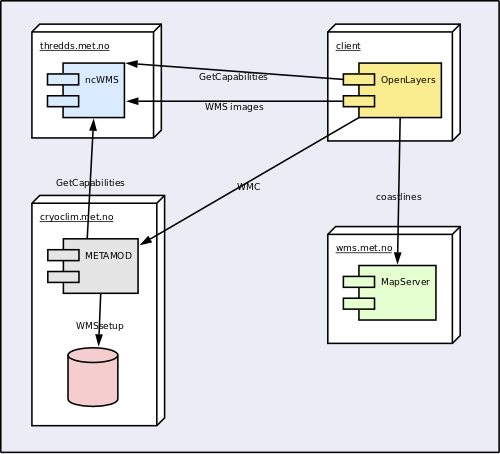
A functional overview of WMS operations, using CryoClim as example:
WMS Client
OpenLayers - JavaScript client for web. Uses extended WMC support library developed by met.no.
WMS Server
NcWMS - integrated with THREDDS. Cannot render shapes, only grids.
http://www.resc.rdg.ac.uk/trac/ncWMS/
MapServer - used on wms.met.no for displaying coastlines
METAMOD WMC generator
Perl proxy/web service. Merges GetCapabilities and WMSsetup file using XSLT. Also works as proxy to get around security limitations in JavaScript.
Protocols and formats
WMS
The OpenGIS® Web Map Service Interface Standard (WMS) provides a simple HTTP interface for requesting geo-registered map images from one or more distributed geospatial databases. A WMS request defines the geographic layer(s) and area of interest to be processed. The response to the request is one or more geo-registered map images (returned as JPEG, PNG, etc) that can be displayed in a browser application.
WMS example
GetCapabilities
XML document describing all available layers and styles in a single data file. Lacks projection and bounding box info.
Example Capabilities document
Web Map Context
XML document specifying desired presentation in client. Can merge layers from different sources, with only desired layers and corresponding styles.
Example WMC document
(currently not deployed outside Met.no firewall)
